THE SCOTTISH
G E O G R A P H I C A L
MAGAZINE
PUBLISHED BY THE SCOTTISH GEOGRAPHIC SOCIETY AND EDITED BY
HUGH A. WEBSTER AND ARTHUR SILVA WHITE
V O L U M E I: 1885
EDINBURGH
PRINTED BY T. AND A. CONSTABLE, PRINTERS TO HER MAJESTY,
AT THE UNIVERSITY PRESS
1885
USE OF CYLINDRICAL PROJECTIONS FOR GEOGRAPHICAL,
ASTRONOMICAL, AND SCIENTIFIC PURPOSES.
BY THE REV. JAMES GALL, EDINBURGH
The value of cylindrical projections have been somehow overlooked;
and although Mercator's is only one of several, each of which has its own peculiarities
and advantages, yet, until lately, it was the only one known.
There are three, but only three things, in which a cylindrical
projection can be perfect; and these depend upon the way in which the latitudes are drawn.
1. We may obtain perfect orientation by rectifying the
latitudes throughout, as Mercator has done; and this is especially valuable for
navigation. But in order to obtain perfect orientation everything else must be sacrificed.
2. Wee may obtain comparative area with mathematical accuracy
by projecting the latitudes orthographically. But in order to obtain comparative area we
must sacrifice everything else.
3. We may obtain accurate polar distance by projecting the
latitudes isographically, that is, at equal distances. But, in order to obtain this,
everything must be sacrificed.
My attention was first drawn to the subject in connection with
astronomy. I had published An Easy Guide to the Constellations, in which each
constellation had a page for itself; and it became necessary for me to publish an Atlas
of the Stars* to show their connection. In planning the atlas, it
occurred to me that a magnificent panorama of the stars, including three-fourths of the
heavens, might be brought into one map by using a cylindrical projection, with the
latitudes drawn stereographically and rectified at the 40th parallel. The result was, that
the constellations on the 40th parallel were absolutely perfect in both hemispheres, and
although those at the equator were a little contracted and those beyond the 40th degree a
little expanded, the errors were so small as not to be observed.
One great advantage which this projection has over every other is, that
several astronomical problems can be solved upon it, the same as on a globe.
It then occurred to me that the same, or a similar projection, would
give a complete map of the world, which had never been done before; and, on drawing a
projection with the latitudes rectified at the 45th parallel, I found that the
geographical features and comparative areas were conserved to a degree that was very
satisfactory.
Having more closely studied the subject, I read a paper before the
British Association in 1855, and exhibited the three new projections - the Stereographic,
the Isographic, and the Orthographic; but I had not then thought of the supplemental
diagrams, which add so much to the value of the Stereographic.
The Stereographic projection has this advantage over all the others,
that it leaves room for supplemental diagrams at the top, on the same scale and on the
same projection, which take up the extremities of the general map, and show their
convergence towards the pole.
GALL'S STEREOGRAPHIC PROJECTION |
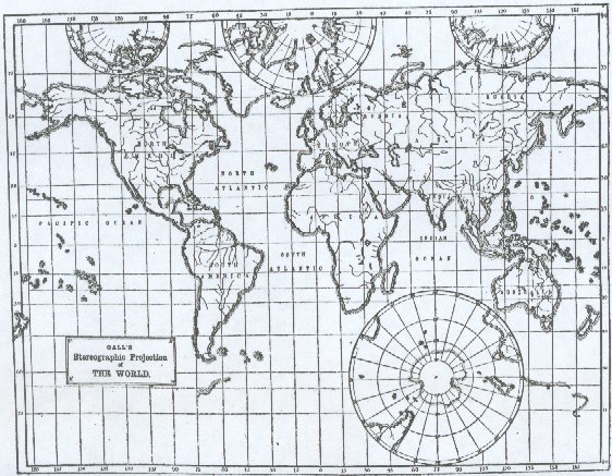 |
The Orthographic projection also is a valuable map for showing the
comparative area occupied by different subjects, such as land and water, as well as many
other scientific and statistical facts. It is true that the geographical features are more
distorted on this than on any of the others, but they are not distorted so as to be
unrecognizable; and so long as that is the, case, its advantages are not too dearly
bought.
GALL'S ORTHOGRAPHIC PROJECTION |
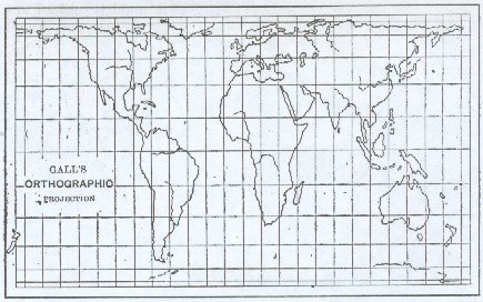 |
I have wondered why geographers never thought of
using the Isographic projection with the latitudes rectified at the 45th parallel. Even
for general purposes it is better than Mercator's, and still more for physical maps, where
polar distance and comparative area are all-important. It is very simple, its geographical
features are on the whole very good, although not so good as in the Stereographic; and for
isothermal and other lines connected with climate, as well as for comparative area, it is
greatly superior to Mercator's.
For general purposes, however, the Stereographic is best of all; for
though it has none of the perfections of the others, it has fewer faults, and combines all
the advantages of the others in harmonious proportions. It
does not give perfect
orientation like Mercator, bat it gives it better than the other two. It
does not give
exact polar distance like the Isographic, but it gives it better than the other two; and
it does not give comparative area like the Orthographic, but it gives it better than
Mercator, though not better than the Isographic. The consequence is, that even without the
supplementary diagrams, the geographical features of the earth's surface are better
conserved than in any of the others; while, with the supplementary diagrams the polar
regions are as accurately and symmetrically represented as the equatorial.
The Stereographic projection, though inferior to Mercator's for
navigation, is superior to it in the following particulars:-
1. On Mercator's projection the whole world cannot be represented,
because as we approach the poles the difficulty increases; and after passing the 80th
degree the map begins to run wild. For that reason, from ten to fifteen degrees of
latitude are generally left out. On the Stereographic projection the whole world is
represented from pole to pole.
2. In Mercator's projection there is a great waste of room. Nearly one
half of the map is occupied with a vain attempt to represent the Arctic and Antarctic
regions, while the habitable world is confined to a comparatively narrow stripe in the
center. In the Stereographic there is no waste of room.
3. In Mercator's projection, the comparative areas are grossly
misrepresented. For example, Spitzbergen appears to be three or four times larger than
Borneo, whereas in reality it is five or six times less. In the Stereographic they appear
in their true proportions.
4. In Mercator's projection the polar distance is not only practically
bat theoretically ignored. The 9Oth degree is nowhere. This makes it peculiarly unsuitable
for physical maps.
5. In Mercator's projection the polar regions have no resemblance to
the reality. In the Stereographic they are as accurately represented as the equatorial.
It is always difficult to introduce changes when long established
custom has created a rut; and for more than twenty years after I had exhibited the three
new projections before the British Association I was the only person that used them. But
at that time I had not added the supplementary diagrams which add so mach to the value of
the Stereographic projection.
The first to adopt it was the late lamented Mr. Keith Johnston, who
introduced it into his miniature Atlas, which was, I believe, the first of his
publications. The next to adopt it were Messrs. Chambers and Mr. Bartholomew, who has done
more than any other to make it known. After them it was adopted by Messrs. Nelson, Messrs.
Gall and Inglis, and Mr. Heywood of Manchester. The late Dr. Keith Johnston when he saw it
gave his hearty approval, and said that his only surprise was that it had never been
thought of before.
GALL'S ISOGRAPHIC PROJECTION |
 |
I do not know whether there is any copyright in new projections. I hope there is not. But if there is, I wish it to be known that I make no pretensions to it, and that every person is welcome to use them. All that I would ask is that, when they are used, my name may be associated with them, and that they may be severally distinguished as Gall's Stereographic, Isographic, and Orthographic Projections of the World.
* In a series of Astronomical Charts which I drew for the Messrs. W.
& A. K. Johnston, I adopted the Stereographic Cylindrical Projection for the
Equatorial and Sub-Equatorial heavens.
Authors are alone responsible for their respective Statements.
Request to post this document on my homepage:
Von: "Jürgen HEYN" <j.heyn@gmx.de>
An: <RSGS@strath.ac.uk>
Betreff: Request kind permission ...
Datum: Sonntag, 16. Februar 2003 17:45
Ladies and gentlemen,
I am aware of violating the copyright is NOT a peccadillo and "ignorance does not protect me from penalty". Therefore I request your kind permission.
As my hobby I am working on a dissertation about the difference between the map projection of Rev. James Gall (1885) and Arno Peters (1967).
More than half a year ago you were so kind to send me a copy of the article from the "Royal Scottish Geographical Magazine", Volume I, 1885 in which Rev. James Gall describes his map projections.
I would like to publish this article on my homepage which is a pure private and non-commercial internet presentation.
I would greatly appreciate if you would approve my request.
Attached a *.zip archive which contains the exact layout of the intended presentation.
Best regards
Juergen Heyn, Wilhelmshaven, Germany
Von: "RSGS" <rsgs@strath.ac.uk>
An: "Jürgen HEYN" <j.heyn@gmx.de>
Betreff: Re: Request kind permission ...
Datum: Montag, 17. Februar 2003 16:36
Dear Mr Heyn
Thank you for your e-mail requesting permission to post the article from SGM Vol I on your website. I am quite happy to grant permission on behalf of the Royal Scottish Geographical Society provided the source of the article is quoted as well as our permission. I look forward to seeing the results of your research work in due course.
Sincerely
Dr David Munro
Director RSGS
Tel: 0141 552 3330
Fax: 0141 552 3331
Email: rsgs@strath.ac.uk
Website: www.rsgs.org
The RSGS is an Educational Charity whose aims are to advance the science of Geography and create a greater understanding of the wider world in the belief that geographical knowledge makes a significant difference to the way in which we view and shape the world we live in.
Scottish Charity No. SCO15599